Beacon Hill and the Old Road
A country walk from the churchyard across the fields to Beacon Hill and its Bronze Age barrow, along the ridge, and back by the Old Road and Holloway Farm.
| Distance | 4.3 miles (6.9 km) |
|---|---|
| Time | About 2 hours 30 minutes |
| Start and finish | The lych gate of St Laurence’s Church, Church Walk |
| Terrain | Field paths, a steady climb of about 120 metres to the top of Beacon Hill, and a stony byway. Five stiles and three kissing gates. Muddy in winter; boots recommended. |
| Access | Not suitable for wheelchairs or pushchairs. The Old Road is open to farm vehicles. |
| Toilets and refreshments | None after the churchyard. Toilets at the museum and the Riverside car park. |
Open the map full size (SVG image, for zooming or printing)
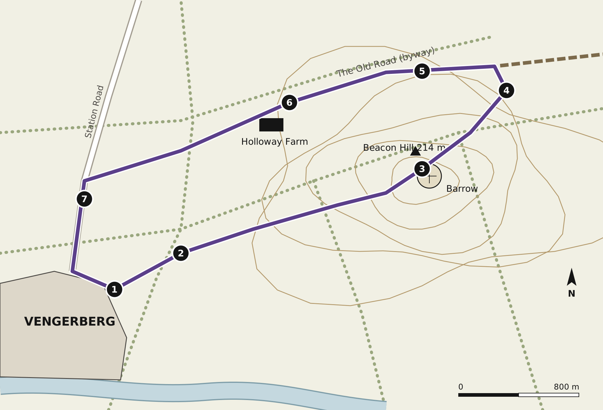
The stops
The lych gate
Leave the churchyard by the stile in its north-east corner and follow the footpath sign across the first field, keeping the hedge on your left.
Long Leasow
The big field beyond the second stile is Long Leasow, named in the borough survey of 1634. The ridges and furrows of the medieval open field still show in low sunlight. Keep straight on uphill to the kissing gate.
Beacon Hill and the barrow
The top of the hill, 214 metres above sea level, is crowned by a round barrow of the Bronze Age, partly dug into in 1851. The museum thinks the town’s name comes from it: Wengeberge in the Domesday survey, probably “Wenga’s barrow” or “Wenga’s hill”. A beacon was lit here for the coronations of 1902, 1937, 1953 and 2023.
The ridge
Follow the ridge north-east. On a clear day you can see the Pontar valley for about twelve miles downstream, and the line of the river picked out by its willows.
The Old Road
Turn left on to the Old Road, a sunken byway that was the main road into the town until the turnpike was made in 1768. In places the banks are higher than a person.
Holloway Farm
The farm takes its name from the hollow way. Its gooseberries have gone into the Lilac Fair cordial since the stall began in 1953. Please keep to the byway through the farmyard.
Station Road
The Old Road comes out on Station Road. Turn left and walk downhill past the old grammar school buildings of 1909, now the primary school, back into the town and up Church Walk to the lych gate.
The printed leaflet for this walk is 50p from the museum desk. Please follow the countryside code: close gates, keep dogs on leads near livestock, and take litter home. Please keep to public paths and respect the privacy of residents, particularly at the almshouses. If you find something on the route that has changed, please tell us at the museum desk.