The Town Trail
The museum, the Market Square and the statue, the mill, the bridge, the quay, St Laurence’s Church and the almshouses.
| Distance | 2.1 miles (3.4 km) |
|---|---|
| Time | About 1 hour 30 minutes, with time at each stop |
| Start and finish | Vengerberg Museum, Sheep Street |
| Terrain | Pavements and surfaced paths. The riverside path between the mill and the bridge is gravel and can be muddy after rain. Church Walk climbs gently for about 150 metres. |
| Access | Step-free throughout if you follow the step-free notes at stops 5 and 7. Two kerbs without dropped edges on Water Lane. |
| Toilets and refreshments | Toilets at the museum and in the Riverside car park. Cafés on High Street and at the Town Mill. |
Open the map full size (SVG image, for zooming or printing)
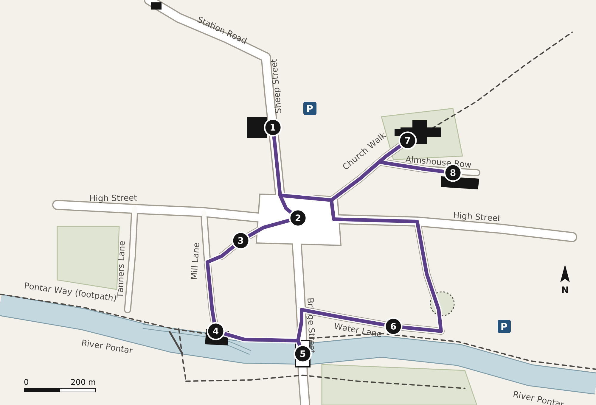
The stops
Vengerberg Museum, the Old Grammar School
The trail starts at the Sheep Street door. The date stone above it reads 1558, the year the free grammar school opened under the will of Thomas Corbet, wool merchant. Look at the iron boot scraper beside the step: the school’s rules of 1712, in the Old Schoolroom, fined boys a penny for coming in with mud on their shoes.
The Market Square and the statue
The Thursday market has been held here under the charter of 1252, granted to the lord of the manor by Henry III. The statue in the centre was unveiled on 19 May 1898. It shows the woman the town calls the Lilac Sorceress, cloaked, holding a spray of lilac towards the bridge. The two lilacs either side of the steps are planted and replaced by the Trust. See The statue and The legend.
The Shambles
The narrow lane off the south-west corner of the square was the butchers’ row. The stalls were roofed over in 1690 and the last butcher left in 1958. Number 4 still has the hooks under its eaves, and the gutter down the middle of the lane is the original one.
The Town Mill
A mill is recorded on this site in 1086. The present building is of 1784, raised a storey in 1871, and ground corn and then animal feed until 1962. The leat that drives the wheel leaves the river above the weir; you can see the wheel through the glass panel in the café floor. From the mill, follow the Pontar Way east along the river.
The Town Bridge and the flood marks
Five arches, the two northern ones medieval, the rest rebuilt after the bridge was widened in 1771. Go down the steps on the upstream side to see the flood marks cut into the third pier: 1648, 1795, 1852, 1947 and 2007. The highest, 1648, is 2.64 metres above the river’s summer level.
Step-free: the marks can be seen across the water from the Pontar Way, just west of the bridge, where there is a bench.
The Town Quay
Barges unloaded coal and timber here until the 1920s. The Flood Bell, now in the museum, hung in a frame by the quay master’s hut and was rung when the river rose. The quay has visitor moorings with a 48-hour limit. Walk on to Castle Lane and turn left up the hill past the Castle Mound.
St Laurence’s Church
Up Church Walk, under the lilacs, to the parish church. The tower is fourteenth-century and the spire was rebuilt in 1866. Inside, the north aisle has the window with violet glass that the town connects with the legend. The church is open daily from 9.00 until dusk. See St Laurence’s Church.
Step-free: use the ramp at the south porch, reached by the path on the right of the churchyard.
Corbet’s Almshouses
Eight almshouses round a courtyard, founded in 1611 by Margery Corbet for “eight poor widows of this town”. They are still lived in, so please look from the gateway. The courtyard opens to visitors one weekend in September. Return down Church Walk to the Market Square and Sheep Street.
The printed leaflet, with the same map, is 50p from the museum desk and the visitor information point. Please keep to public paths and respect the privacy of residents, particularly at the almshouses. If you find something on the route that has changed, please tell us at the museum desk.